Project Background and Objectives
Jiangyin City is located in the plain river network area in the northern part of Taihu Lake, with the Yangtze River to the north and Taihu Lake to the south. The terrain is low-lying, receiving floodwaters from Taihu Lake and Xiyu District upstream, while being subject to high tides from the Yangtze River downstream, making it vulnerable to flooding during the flood season.
Over the years, Jiangyin City has continuously strengthened and improved its urban flood control and drainage system. It has now developed a flood control and drainage system that relies on the Yangtze River embankments on the periphery, with internal drainage from highlands and intensive pumping from low-lying areas through a network of key rivers, pumps, and sluices.
In recent years, with the acceleration of urbanization in Jiangyin City and Wucheng Xiyu District, as well as changes in water conservancy project construction and dispatching schemes, new challenges have emerged for flood control and drainage in Jiangyin City.
Ewaters assisted the city in improving the concepts and skills of comprehensive water management and decision-making processes based on advanced data mining techniques.
Main Services:
River network model build. Ewaters developed a river network model integrating advanced urban water management concepts. This model covers the entire Jiangyin City, spanning a total area of 987.5 km2, including 811.7 km2 of land and 175.8 km2 of water. Simulate water level conditions in township rivers across different regions, enabling the scientific formulation of flood control strategies, risk avoidance measures, and scheduling decisions.
Hydrological information monitoring system development. Analyze and evaluate the water conditions and potential of the river network under historical rainfall in Jiangyin City. This includes identifying risk situations, weak links, bottleneck areas, and key facilities within the township river network, and determining the direction and content of tasks requiring further attention.
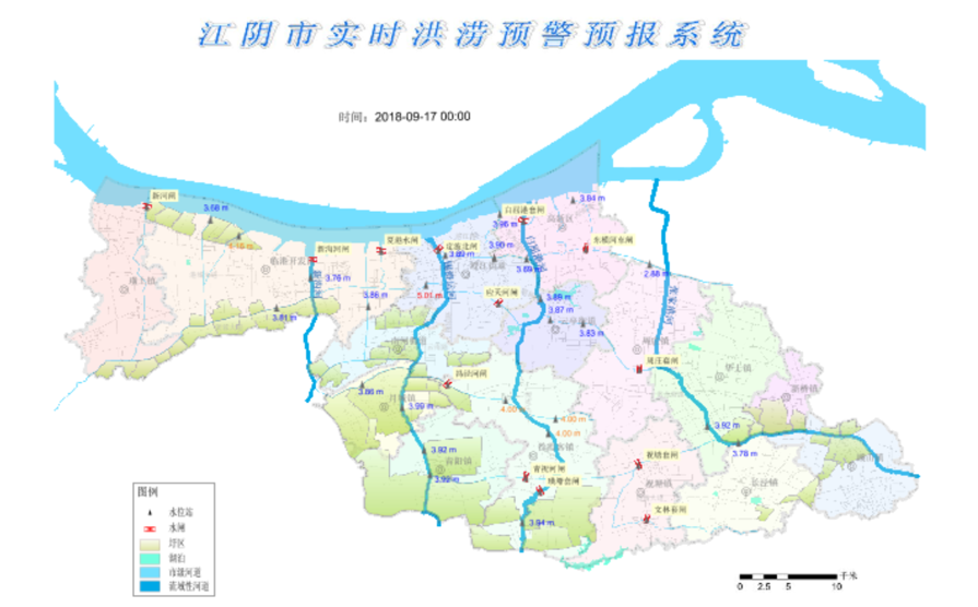
Real-time early-warning and forecasting system development. Establish a real-time early-warning and forecasting system for the river network based on the FEWS platform to determine the risk levels of different river channels. This system will scientifically formulate emergency plans for flood control, and issue warnings for disaster avoidance objects, places, and routes under varying rainfall events.
Joint operation of sluice pump facilities optimization. Optimize the joint operation of river network sluice pump facilities to enhance the overall drainage and waterlogging prevention capacity of Jiangyin City, thereby reducing the consequences of disasters.